





Sunrise and sunset vantage points above the Bangladesh plains
Perched high on the wind-scoured plateau of Meghalaya, the village of Cherrapunjee looks out across one of the most extraordinary horizons on the subcontinent. Within a single turn of the head you can watch monsoon clouds boiling up over the Khasi Hills and, on a clear morning, trace the green quilt of farmland that fades into the distant plains of Bangladesh. Few experiences match the hush that falls over the cliff edge as the first orange line appears above Sylhet, or the slow burn of amber that paints the lowlands as evening settles in over Dhaka.
For Australian travellers who have grown up watching the sun drop behind the Blue Mountains outside Sydney or rise over the surf at Bondi, the appeal of a foreign horizon written in a completely different palette is hard to resist. The short hop from an Australian winter to Meghalaya's cool dry season means you can swap a grey July morning in Brunswick for a January dawn above one of the oldest rock formations on Earth. Pack the right gear, time the drive carefully, and you will find a vantage point that no Bondi postcard can match.
How the Khasi escarpment creates this rare view
The geography behind the spectacle is simple but striking. The Khasi Hills rise abruptly from the Surma-Meghna river plain, which sprawls across most of eastern Bangladesh. Within a few kilometres the elevation climbs from around fifteen metres above sea level to more than 1,800 metres at the highest peaks near Cherrapunjee. Because the slope is so steep and the plateau above it so flat, almost any westward-facing clifftop becomes a natural amphitheatre looking straight out over the lowlands.
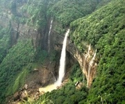
Geologists often point to this same formation when explaining why Cherrapunjee holds the world record for the wettest place on Earth. The monsoon air, funnelled up the escarpment, condenses violently over the plateau and unloads its moisture before drifting on. That same cliff wall, however, also acts as a viewing gallery once the rains ease. Travellers driving the few hours from Guwahati airport to Sohra quickly realise that the road itself is part of the experience, with hairpin bends that frame the distant plains between the tree ferns and bamboo groves.
This is also why so many Australians who normally chase coastal scenery end up drawn here. A country built around long drives, lookouts and the ritual of pulling over for a thermos of coffee at dawn finds its mirror image in the Khasi plateau. The cliffs deliver what the Twelve Apostles or the Pinnacles promise back home, but with a completely different colour palette and a backdrop of subsistence rice fields rather than the Southern Ocean.
Where to catch the first light
The sunrise side of the plateau faces east, away from Bangladesh, but the interplay of light at dawn is what makes the eastern viewpoints unforgettable. Mist pours off the escarpment like a waterfall in slow motion, often spilling into the valleys that drain toward Sylhet. A handful of easily reached points have become favourites among photographers and early risers willing to be on the road by five in the morning.
A short selection of sunrise vantage points worth setting the alarm for:
- Wei Sawdong, where the river gorge opens up beneath a level platform and the sun climbs through river fog.
- The Mawsmai Cave overlook, where the limestone cliffs glow pink before the day warms up.
- The drive-in pull-off near Mawkdok, popular with tour vans because the viewing platform is wide enough for tripods.
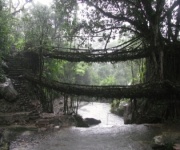
- The single-tree ridge above Nongriat, where you can watch the living root bridges emerge from the mist as light strengthens.
- The school playground at Cherrapunjee itself, surprisingly clear and far less crowded at dawn than during the day.
Photographers from Melbourne's Brunswick and Fitzroy studios often remark that the soft dawn light here behaves much like the pre-sunrise glow they chase over Port Phillip Bay, only with five times the vertical relief and a layer of monsoon moisture still clinging to the ferns.
Watching the sun sink toward Dhaka
Sunset is the other half of the ritual, and arguably the more dramatic. As the day cools, the air above Bangladesh thickens with haze and humidity, and the sun seems to set in slow motion behind the invisible line where the plains meet the sky. Looking west from Cherrapunjee, the sun appears to drop directly toward Dhaka, more than two hundred kilometres away, though the city itself is usually lost in the haze.
Favourite sunset vantage points along the plateau include:
- The cliff edge near the Cherrapunjee viewpoint, where most tour groups gather for the evening ritual.
- The garden terrace at a clifftop resort, often used for sundowners with a view of the lowlands.
- The ridge above Mawlynnong, often billed as Asia's cleanest village, where the light lingers over the rice fields.
- The road pull-off between Sohra and Dawki, where the cliffs face directly into the setting sun.
- The approach to the Bangladesh border viewpoint near Tamabil, which requires permits but offers the most direct line of sight.
For Australians used to driving hours along the Great Ocean Road to find the perfect sunset angle, the experience of pulling over on a quiet Meghalaya road and watching the same ritual play out half a world away can feel quietly profound. There is also a strong conservation undertone to the experience, and regional groups such as the regional conservation network often highlight how cross-border tourism can fund the protection of forests that, in turn, stabilise the climate of the lowlands below.
Weather, monsoon and the clear-season window
The biggest mistake travellers make is showing up in the wrong season. The Cherrapunjee region records more than 11,000 millimetres of rain in a heavy monsoon year, and during the wet season the plains of Bangladesh vanish behind a wall of cloud for days at a time. Visibility can collapse to a few metres, and the cliff roads become slippery and occasionally impassable. The window for clear horizons is narrow but predictable.
The best months run from late October through early March, with December and January offering the clearest air and the longest stretches of cloudless afternoons. Mornings can still be cold on the plateau, with temperatures dipping close to single digits, so layered clothing is essential. Australians packing for an outback road trip in winter will find the packing list familiar: a fleece, a wind shell, a beanie and sturdy shoes for the muddy trails leading down to the root bridges.
It also helps to time your arrival around a high-pressure system. Local guides in Sohra know the signs and will tell you which week the air is likely to clear. Travellers from Perth, where clear winter days are a given, often find Meghalaya's dry season particularly rewarding since the lighting conditions feel closer to home, just inverted across the equator.
Travelling from Australia to the edge of Meghalaya
Getting to Cherrapunjee from Australia takes planning but is increasingly straightforward. Most travellers fly from Sydney or Brisbane via Singapore, Kuala Lumpur or Bangkok to Guwahati, the gateway airport for Meghalaya. The drive from Guwahati to Cherrapunjee takes roughly four hours through hill roads that twist past pineapple plantations and bamboo clusters, with a compulsory stop for tea at a roadside stall.
A few practical realities shape the trip for Australians. The Indian e-Visa is available to Australian passport holders and is the simplest route through immigration. The Australian government's Smartraveller advisory for India encourages travellers to register their trip before departure and to carry copies of their passport and visa. Domestic Australian rules around the goods and services tax do not apply once you leave the country, but travel insurance is strongly recommended, particularly given the long internal drive from Guwahati and the limited medical facilities on the plateau. Travellers should also be aware of Australia's strict biosecurity laws when returning home, as any soil, plant material or food carried back from a farm visit must be declared on arrival.
For those watching their budget, the the best budget guesthouses with free breakfast in Cherrapunjee offer a useful starting point, with simple rooms and home-cooked meals within walking distance of the main sunrise and sunset pull-offs.
Extending your journey beyond the viewpoints
Once you have ticked off the sunrise and sunset rituals, the rest of the plateau opens up. Living root bridges at Nongriat and Riwai, the crystal-clear waters of the Umngot River at Dawki, and the limestone caves at Mawsmai and Arwah are all within a half-day drive. Combining these with Cherrapunjee produces a four to five day itinerary that feels unhurried, with long morning walks and lazy afternoons in the clouds.
A common pattern for Australian travellers is to book a longer tour package from Sydney or Melbourne that begins in Delhi or Kolkata, includes a few nights in Cherrapunjee, and finishes with a beach stop in Goa or the Andamans. The contrast between the clifftop dawns above Bangladesh and the slow tropical evenings on India's coast tends to anchor the memory of the trip long after the flight home.
The plains of Bangladesh will keep doing what they have always done, soaking up monsoon rain and shimmering under the late afternoon sun. From the right vantage point, however, that ancient rhythm becomes a personal ritual, a moment of stillness shared with travellers from every corner of the planet, including the growing number of Australians who have discovered that some of the world's most extraordinary horizons are waiting quietly at the eastern edge of India.