





Cherrapunjee’s Hidden Gems: Waterfalls You Won’t Find on Tourist Maps
Cherrapunjee, also known as Sohra or Cherrapunji, is famous for dramatic cliffs, cloud-covered plateaus and some of the wettest landscapes on earth. Its best-known waterfalls draw visitors to viewpoints and roadside stops, yet the wider Sohra region holds many smaller cascades, forest falls and remote plunges that receive far less attention.
Some of these waterfalls are absent from ordinary sightseeing itineraries because they require a village walk, a steep descent, a local guide or a willingness to travel beyond the standard circuit. Others appear only after heavy rain, flowing through mossy ravines that can look almost dry during the winter months.
Exploring them is less about collecting photographs and more about understanding Meghalaya’s living landscape. Water moves through sacred groves, limestone valleys, betel-nut gardens and Khasi villages, while narrow paths connect places that are rarely marked on commercial tourist maps. The reward is a quieter and more personal side of Cherrapunjee.
Beyond the Famous Sohra Viewpoints
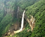
Nohkalikai Falls, Nohsngithiang Falls and Dainthlen Falls remain essential sights for first-time visitors. Their viewpoints are comparatively easy to reach, and each offers a different view of the plateau’s geology. However, the concentration of visitors around these landmarks can make it easy to assume that Sohra’s waterfall experience ends at the main roads.
The quieter falls are usually found where the plateau breaks into deep valleys. Roads may lead close to a village, but the final approach often involves rough tracks, stone steps or forest paths. A waterfall may have several local names, and the spelling can vary between maps, drivers and villages. This is one reason online directions can be incomplete or confusing.
A visit to Laitlum Canyon views can also complement a waterfall-focused journey, especially for travellers interested in Meghalaya’s ridgelines and ravines. Laitlum is outside the central Sohra waterfall loop, but its broad canyon scenery helps explain how streams become the plunging cascades seen across the plateau.
Falls Worth Seeking Out
Wei Sawdong is one of the most rewarding lesser-known stops near Sohra. The waterfall drops in several levels into vivid blue-green pools, surrounded by steep rock walls and dense vegetation. A staircase leads down to the falls, so the return climb can be demanding, particularly after rain when the steps are slippery.
The colour of the pools changes with sunlight, sediment and water flow. Visitors should avoid treating the lower pools as automatically safe for swimming, since currents can strengthen quickly during rainfall. Early arrivals generally have a better chance of enjoying the site in relative quiet before day-trip vehicles begin to appear.
Langshiang Falls offers a different experience. Located in the western part of the Sohra region, it is associated with a broad, rugged landscape rather than a single polished viewpoint. The waterfall and surrounding valley are best approached with local assistance because tracks can be difficult to identify, and the condition of paths varies from season to season.
Rainbow Falls, reached on the longer trail beyond Nongriat, is another memorable option for energetic travellers. The route passes through forest and living root bridge country before continuing toward a waterfall where sunlight can create a rainbow in the spray. The hike involves many steps and uneven ground, making sturdy footwear and adequate drinking water essential.
Forest Paths, Root Bridges And Remote Cascades
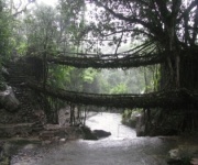
The Nongriat area is known internationally for its living root bridges, but the journey also reveals a network of streams and falls that are easy to overlook. The trail from Tyrna descends through humid forest, crossing bridges and following the contours of a steep valley. Small cascades appear beside the route, while larger falls require additional walking beyond the main bridge area.
The famous double-decker living root bridge is a major attraction, yet it should not be treated as a quick roadside stop. The descent and return ascent can take several hours, depending on fitness, weather and time spent in the village. Travellers planning to continue toward Rainbow Falls should begin early and allow a generous margin before sunset.
The waterfalls around Nongriat are especially atmospheric after rain, when the forest is filled with rushing water and mist. At the same time, wet weather increases the risk of slippery rocks, swollen streams and difficult crossings. Local guides can explain which sections remain passable and which water levels make a particular route unsafe.
Smaller cascades near Sohra often have no formal entrance gate, visitor centre or maintained viewing platform. That lack of infrastructure is part of their appeal, but it also means visitors must take greater responsibility for navigation and conservation. Staying on established paths, carrying waste out and avoiding damage to moss, roots and streamside plants helps preserve these fragile places.
Comparing Access, Effort And Scenery
The best waterfall for a particular traveller depends on available time, fitness, weather and interest in hiking. A short roadside stop can provide spectacular scenery, while a full-day trail offers greater solitude and a closer connection with village landscapes. The table below gives a practical comparison, but conditions can change quickly.
| Waterfall or area | Typical access | Effort level | Best feature | Main caution |
|---|---|---|---|---|
| Wei Sawdong | Vehicle journey followed by a steep stairway | Moderate | Tiered falls and deep pools | Slippery steps and strong currents |
| Langshiang Falls | Drive toward the western Sohra area, then local trail | Moderate to strenuous | Wide valley and remote setting | Unclear paths and limited facilities |
| Rainbow Falls | Long trek beyond Nongriat | Strenuous | Forest journey and spray-filled gorge | Start early; wet rocks and stream crossings |
| Nongriat cascades | Trek from Tyrna through root-bridge country | Moderate to strenuous | Living roots, forest streams and village scenery | Large number of steps |
| Kynrem Falls | Road access near Thangkharang Park | Easy to moderate | Multi-tiered monsoon flow | Visibility varies with season |
| Dainthlen area | Roadside route with short walks | Easy | Dramatic rock formations and broad falls | Crowds at popular viewpoints |
Kynrem Falls is more accessible than the remote trails, yet it can still feel impressive when viewed in the rainy season. Located near Thangkharang Park, it descends in multiple stages through a green valley. Because its flow is seasonal, the surrounding scenery may be more consistent than the waterfall itself during drier months.
Dainthlen Falls is also easier to include in a standard Sohra itinerary. Local legend gives the site a strong cultural identity, while the rock formations and open setting make it different from the enclosed forest falls. Visiting early or later in the day can provide a calmer experience than arriving with the main sightseeing rush.
Choosing The Right Season
The monsoon, generally from June to September, creates Cherrapunjee’s most powerful waterfalls. Streams swell, cliffs turn intensely green and temporary cascades appear along slopes that may be dry at other times. This is the season for dramatic volume, mist and saturated landscapes.
Rain also brings practical complications. Visibility can disappear into cloud, roads may become muddy, and trails can turn slick enough to slow progress considerably. A waterfall that is safe to admire from a viewpoint may be hazardous to approach closely. Flexible plans are important because a local driver or guide may advise changing the route on a particularly wet day.
October to November often offers a useful balance between strong residual flow and more manageable travel conditions. Skies may be clearer, and trails can gradually become easier to negotiate. December through February is generally more comfortable for walking, but some lesser-known falls may have reduced flow.
The drier months are still worthwhile for travellers who value clear valley views, village visits and living root bridges more than maximum waterfall volume. Before setting out, check current local conditions rather than relying only on older photographs. A recent storm, road repair or trail closure can change access rapidly.
Travelling Responsibly In Khasi Country
Many waterfall routes pass through privately used land or communities that have their own customs and expectations. Ask before photographing residents, homes, farms or religious sites. Dress modestly for village visits, keep voices low near sacred areas and follow guidance from local hosts.
A local guide is particularly valuable for remote falls. Guides can identify the correct path, translate where necessary, explain local stories and assess stream conditions. Their knowledge also helps visitors avoid taking shortcuts that damage vegetation or crossing areas that become dangerous after rain.
Pack lightly but deliberately: shoes with reliable grip, a rain jacket, drinking water, snacks, a small first-aid kit, insect protection and a waterproof cover for electronics are useful. Mobile reception can be inconsistent, so do not depend entirely on live navigation. Tell your accommodation or driver where you are going and when you expect to return.
Waste is a serious concern on trails that have little formal maintenance. Carry reusable water bottles where possible and take every wrapper, tissue and food container back to an appropriate disposal point. Do not use soap in natural pools or streams, and avoid climbing on delicate rock edges for photographs.
Building A Waterfall-Focused Itinerary
A two-night stay can cover the major viewpoints and one shorter walk, while three or four nights create room for Wei Sawdong, Nongriat or a more remote western Sohra route. Travellers with five to seven nights can combine waterfalls with caves, parks, village experiences, living root bridges and wider Meghalaya excursions without forcing every day into a rushed schedule.
A practical day might begin with a longer trail while energy is high, followed by a nearby viewpoint in the afternoon. Another day can be reserved for weather-sensitive attractions. This approach is more comfortable than attempting several distant waterfalls in one circuit, especially when rain slows road travel.
For route planning, use a waterfall access map alongside current advice from your accommodation or local operator. Distances on a map do not always reflect driving time, road conditions or the physical effort required after the vehicle stops.
- Choose waterfalls that match your walking ability and available daylight.
- Hire a local guide for remote trails, unfamiliar village paths and Nongriat extensions.
- Carry rain protection, secure footwear, water and a small emergency kit.
- Check weather and stream conditions before leaving, especially during the monsoon.
- Respect village customs, avoid litter and leave natural pools and forest areas undisturbed.
A waterfall-focused Cherrapunjee holiday becomes more memorable when the itinerary leaves space for uncertainty. Clouds may conceal a viewpoint, a sudden shower may transform a small stream, or a local recommendation may lead to a cascade absent from your original plan. Those unexpected moments are often the reason lesser-known routes stay with travellers long after the better-known photographs have faded.
Explore Cherrapunjee with an itinerary shaped around your interests, walking capacity and travel dates. India Beacons Sojourn can help arrange stays, local transport and multi-day Meghalaya packages from two to seven nights, giving you a practical way to discover Sohra’s waterfalls while travelling with respect for its communities and landscapes. Reach out through Cherrapunjee.net to begin planning your waterfall journey.