





The Unique Geology Behind Cherrapunjee’s Extreme Rainfall
Cherrapunjee, also known as Sohra or Cherrapunji, sits on the southern edge of Meghalaya’s Khasi Hills in north-east India. Its dramatic escarpments, limestone caves, deep valleys and living root bridges are often described as separate attractions, yet they are connected by the same powerful combination of rock, relief and monsoon weather. The landscape acts as a natural stage on which moisture-laden air is forced upwards, cooled and transformed into extraordinary rainfall.
For visitors travelling from Australia, the scale can be difficult to imagine. Even during a wet summer in Brisbane or a downpour in Sydney, rain usually arrives as a passing weather system. In Sohra, the south-west monsoon can dominate the landscape for weeks, filling streams, feeding waterfalls and reshaping footpaths. Understanding the geology makes a walk through the region far more meaningful, whether you are staying in a resort, exploring caves or following a trail to a living root bridge.
Rain Meets The Khasi Hills
The primary source of Cherrapunjee’s rainfall is the Bay of Bengal branch of the south-west monsoon. Warm air gathers huge quantities of moisture over the bay before moving north-east towards Bangladesh and Meghalaya. As this air reaches the abrupt southern face of the Khasi Hills, it encounters a steep natural barrier rather than an open plain.
The air is forced to rise along the escarpment. Rising air expands and cools, reducing its capacity to hold water vapour. Condensation follows, producing thick cloud, intense showers and long periods of persistent rain. This is known as orographic rainfall, a process familiar in broad terms to Australians who have seen wetter conditions on the windward side of mountain ranges, although the Khasi Hills experience a far more concentrated monsoon effect.
Sohra’s position is especially important. It lies close to the edge of the plateau, where moist air moving inland from the lowlands meets elevated terrain. Valleys and ridges help channel the air, while the exposed escarpment receives the full force of weather arriving from the south. Nearby Mawsynram is also renowned for extreme rainfall, showing that this is a regional geographical pattern rather than a phenomenon limited to one town.
Limestone, Sandstone And The Shape Of Water
The rocks beneath Meghalaya help explain why rain becomes such a visible feature of the landscape. The region contains layers of limestone, sandstone and shale, formed over long geological periods from sediments deposited in ancient environments. These rocks respond differently to water, creating a varied surface of ledges, gullies, cliffs, sinkholes and underground passages.
Limestone is particularly significant because it dissolves slowly in weakly acidic rainwater. As water passes through cracks and bedding planes, it enlarges them over time. This process, called karst formation, creates caves, chambers and narrow underground channels. Meghalaya’s cave systems are among the most extensive in India, and many remain difficult to access because of their length, darkness and wet conditions.
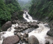
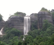
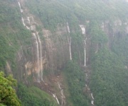
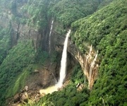
Sandstone and harder rock layers can form shelves over softer material. When streams reach these changes in resistance, water drops suddenly and creates waterfalls. In and around Cherrapunjee, heavy rain quickly feeds cascades such as Nohkalikai, while smaller seasonal falls appear along roads and forest tracks. A waterfall is therefore more than a scenic viewpoint: it is the visible result of rainfall moving across a layered geological structure.
Rain also exploits fractures in the plateau. During intense storms, water gathers rapidly on slopes before entering channels, while porous soils and cracked rock allow some of it to move underground. This combination produces a landscape where surface streams, hidden cave rivers and sudden waterfalls can exist close together.
A Monsoon Landscape In Motion
The geology of Cherrapunjee is still changing. Every monsoon shower carries small particles of soil and weathered rock downhill. Over many seasons, this erosion deepens ravines, widens streambeds and exposes fresh surfaces along cliffs. The process is gradual when viewed across a single holiday, yet its results are dramatic when seen in the form of steep gorges and sharply cut valleys.
The plateau edge also creates a strong contrast between exposed grassland and sheltered forest. Open areas dry quickly during the short period outside the main monsoon, while protected valleys retain moisture for longer. Mosses, ferns and other moisture-loving plants thrive in shaded places, adding a vivid green layer to the geological scenery.
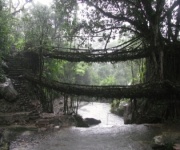
Living root bridges show how local communities have adapted to this wet, rugged environment. Khasi villagers guide the aerial roots of rubber fig trees across streams and ravines, gradually creating bridges that strengthen as they mature. The bridges are biological structures rather than geological formations, yet they belong to the same water-shaped landscape. They cross channels that swell during the monsoon and connect settlements separated by steep terrain.
The relationship between rainfall and rock is also visible in village life. Roads can become slippery, cave entrances may carry flowing water and paths beside waterfalls can change after a storm. Guides are essential in areas where weather can alter conditions quickly. A route that feels straightforward in the drier months may become a demanding walk during the main rains.
Seeing The Geology During Your Stay
The best way to understand the region is to combine viewpoints with time spent at ground level. From an escarpment lookout, visitors can see how the plateau falls towards the plains. At a waterfall, the same rainfall becomes concentrated into a single channel. Inside a cave, the story moves underground, where water has slowly widened cracks and carved passages through limestone.
Travellers from Melbourne or Adelaide may find the monsoon conditions particularly unfamiliar because the wet season does not simply mean occasional showers. Waterproof footwear, a dry bag and a light rain jacket are useful even when the morning looks calm. Quick-drying clothing is more practical than denim, and a sealed phone pouch protects maps and photographs when spray or rain arrives unexpectedly.
A visit also benefits from local interpretation. Guides can explain which paths are safe, how streams behave after heavy rain and where the rock formations are easiest to see. At a viewpoint, it is worth allowing time for cloud to shift rather than expecting a clear panorama immediately. The weather is part of the experience, not an interruption to it.
Food and rest fit naturally into a day of exploring. After a cave walk or waterfall visit, travellers can sample Khasi flavours, rice-based meals, smoked ingredients and local tea. Planning a stop at local cafes adds a practical and cultural dimension to the journey, especially for Australians accustomed to café culture in Sydney, Perth or Brisbane.
Practical Ways To Explore Responsibly
Cherrapunjee rewards careful planning because its attractions are spread across a large, weather-sensitive area. A multi-day itinerary allows time for caves, waterfalls, forests and viewpoints without turning every day into a race between sites. It also gives rain a chance to pass and leaves room for local experiences that are easy to miss on a rushed excursion.
Travellers should consider these practical measures:
- Carry a waterproof day bag, rain cover, reusable water bottle and quick-drying layers throughout the monsoon season.
- Wear shoes with firm grip for wet limestone, muddy paths and uneven steps near caves and living root bridges.
- Use a local guide for cave systems, remote trails and routes affected by fast-flowing streams or recent rain.
- Keep a flexible schedule, since cloud, road conditions and rainfall can alter sightseeing times.
- Choose accommodation with reliable transport arrangements, drying space and access to local advice.
- Bring a small amount of Indian currency for village refreshments, local transport and minor entry charges, while keeping valuables protected.
- Respect village customs, avoid climbing fragile formations and take all rubbish away from forests, streams and cave entrances.
Australians should also remember that local travel operates at a different pace from a self-drive holiday between Sydney and Canberra. Roads may be narrow, travel times can be longer than the map suggests and weather may affect visibility. Modest clothing is appropriate when visiting villages or community areas, and asking before photographing people or private property is a courteous practice.
A well-designed Meghalaya itinerary can connect Sohra with Shillong and other parts of the Khasi Hills. The official travel information and package options at Cherrapunjee travel tours can help visitors compare stays, attractions and trip lengths before arriving. Two to seven nights gives travellers different ways to balance scenic drives, walks, cultural visits and time at their accommodation.
When you stand beneath a waterfall or enter a limestone cave, you are seeing several natural systems working together. Moisture from the Bay of Bengal arrives on monsoon winds, the Khasi escarpment lifts the air, and water then follows weaknesses in the rock. Over time, that movement creates the cliffs, caves, gorges and streams that define Sohra.
Book a journey that gives this landscape time to reveal itself. With suitable clothing, local guidance and a flexible itinerary, Cherrapunjee becomes more than a place famous for rain: it becomes a living lesson in how climate and geology shape a destination.