|
|
|
|
|
Home
|

|
History of Cherrapunjee
|
|
|
|
|
|
|
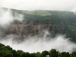
The original name of Cherrapunjee was Sohra,
which was pronounced "Churra" by the British. This name eventually
evolved into the current name, Cherrapunji. Located at nearly 4,500 feet above the sea-level on the summit of the southern ranges of Khasi
hills overlooking the vast plains
of Sylhet (Bangladesh), Cherrapunjee is one of the must visit destination especially during monsoons.
The word "Cherrapunji"
means 'land of oranges'. Despite perennial rainfall, Cherrapunji faces an acute
water shortage and the inhabitants often have to trek for miles to obtain
potable water.
Irrigation is also hampered due to excessive rain washing away the topsoil as a
result of human encroachment into the forests. The Meghalaya state government
has renamed Cherrapunjee back to its original name, "Sohra". There is
a monument to
David Scott
(British Administrator in NE India,
1802–31) in the Cherrapunji cemetery. The history of the Khasis – the
inhabitants of Cherrapunji – may be traced from the early part of the 16th
century. Between the 16th and 18th centuries these people were ruled by the '
Syiems
(rajas or chiefs)
of Khyriem'
in the
Khasi hills
.
The Khasi hills came under British authority in 1883 with the submission of the
last of the important syiems, Tirot Singh.
|
|
Other Tourist Attractions
|
|
|
|
|
|
All Images and Content on this website are the intellectual property of India Beacons Sojourn.
No replication or usage of any of the images and content is allowed without prior written authorization.
Copyright (c) 2012 www.indiabeacons.com
All rights reserved. Created and maintained by Anubha Rathore
|
|
|
|
|