




The History of Cherrapunjee From British Era to Today
Cherrapunjee, widely known by its traditional name Sohra, is often introduced through dramatic rainfall, mist-covered hills, waterfalls, and living root bridges. Yet its appeal extends far beyond scenery. The region carries the memory of Khasi communities, colonial administration, Christian missions, resistance movements, changing capitals, and a modern tourism economy shaped by both culture and climate.
Sohra stands on the southern edge of the Khasi Hills in Meghalaya, overlooking the plains of present-day Bangladesh. Its steep escarpments made it a natural meeting point between hill communities and lowland trade routes. Long before hotels and sightseeing packages appeared, the area was sustained by village institutions, farming, forest knowledge, oral traditions, and networks connecting Khasi settlements.
The name “Cherrapunjee” became prominent during the colonial period, while “Sohra” remains deeply connected to local identity. Understanding the transition between these names is part of understanding the wider story of the place: a hill settlement transformed into a British administrative centre, then into a symbol of Meghalaya’s living heritage and a destination for travelers from across India and abroad.
Sohra Before Colonial Rule
Before British influence reached the Khasi Hills, Sohra was part of a landscape governed through local chiefs, village councils, customary law, and clan relationships. Khasi society was not organized as a single centralized kingdom. Instead, different territories were associated with traditional chiefs, often called syiems, whose authority operated alongside community institutions and customary practices.
The region’s location gave it strategic importance. Routes descended from the plateau toward the markets and river plains of Sylhet, creating opportunities for trade in limestone, forest products, oranges, betel nut, honey, and other goods. The escarpment was also a cultural boundary, separating the highlands from the warmer lowlands below. Seasonal movement between these zones shaped local agriculture and commerce.
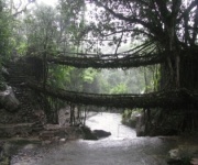
Khasi communities developed sophisticated ways to live with intense monsoon conditions. Houses, paths, cultivation methods, and water systems reflected close observation of the environment. The famous living root bridges emerged from this long tradition of ecological engineering. Made by guiding the aerial roots of rubber fig trees across streams and ravines, they demonstrate how local knowledge adapted to a wet, rugged terrain without relying on imported construction methods.
British Expansion And The Khasi Resistance
British involvement increased after the Treaty of Yandabo in 1826, which expanded British control in northeastern India following the First Anglo-Burmese War. The colonial administration wanted dependable communication routes between the Brahmaputra Valley and Sylhet. A road across the Khasi Hills became a major objective, bringing British officials and military interests into closer contact with Khasi territories.
Many Khasi leaders opposed the road because it threatened political independence and could open the hills to permanent outside control. The most prominent resistance was associated with Tirot Sing, the syiem of Nongkhlaw. Conflict broke out in 1829 after tensions over British movement and the construction of a military road. Khasi resistance continued for several years, using knowledge of the terrain to challenge better-equipped forces.
The Anglo-Khasi conflict was eventually suppressed, but it remains a central part of regional memory. Tirot Sing is remembered as a defender of Khasi sovereignty, and commemorations continue to connect his struggle with wider ideas of identity and self-determination. Visitors exploring the area encounter a history that cannot be reduced to colonial buildings or administrative dates; it also includes the voices of communities negotiating pressure from a powerful expanding state.
Cherrapunjee Under British Administration
After the resistance, the British consolidated their presence in the Khasi Hills. Cherrapunjee became an important administrative and military station because of its elevation, strategic position, and access to the southern plains. It served as the headquarters of the Khasi and Jaintia Hills for much of the nineteenth century and became one of the best-known hill settlements in the region.
Colonial records frequently used the name Cherrapunjee, an anglicized form connected to Sohra. British officers documented the area’s extraordinary rainfall, landscape, geology, and communities. The settlement also attracted missionaries, educators, surveyors, and travelers. Roads, administrative structures, churches, schools, and other institutions altered the appearance and functions of the town.
The rainfall became central to the colonial identity of the place. Cherrapunjee gained international attention through measurements that recorded exceptional monsoon totals, including remarkable rainfall during the nineteenth century. Its reputation as one of the wettest inhabited places on Earth helped place it in scientific and travel writing far beyond the Khasi Hills. A closer look at Sohra’s rainfall record reveals how geography, seasonal winds, and the Khasi escarpment combine to produce this extraordinary climate.
Missionaries, Education And Social Change
Welsh missionaries arrived in the Khasi Hills during the nineteenth century, with Thomas Jones becoming one of the best-known figures after reaching the region in 1841. Missionary work introduced new forms of schooling, religious instruction, printing, and written communication. The development of Khasi-language materials played a lasting role in education and literary culture.
Christianity expanded in parts of the Khasi Hills, although conversion was a gradual and complex process. Mission schools offered opportunities for literacy and employment, while traditional beliefs, customary institutions, and community practices continued to shape everyday life. The encounter between Khasi society and missionary organizations therefore produced both change and adaptation rather than a simple replacement of one culture by another.
The colonial era also brought new systems of taxation, law, mapping, and administration. These systems affected land, labor, commerce, and political authority. At the same time, Khasi communities preserved oral histories, clan traditions, music, weaving, foodways, and environmental knowledge. Modern Sohra reflects this layered past, with churches, colonial-era traces, indigenous customs, and contemporary institutions existing within the same cultural landscape.
From Colonial Centre To Meghalaya Destination
The British eventually shifted the headquarters of the Khasi and Jaintia Hills from Cherrapunjee to Shillong in 1864. Shillong offered a more moderate climate and became increasingly important as an administrative centre. The move reduced Cherrapunjee’s official prominence, although its name remained famous because of rainfall and its dramatic setting.
The twentieth century brought wider political changes. After Indian independence in 1947, the region became part of Assam, while movements for greater autonomy gathered strength among the hill communities. Meghalaya became an autonomous state in 1970 and a full state of India in 1972. Sohra’s history thereafter became part of the larger story of Meghalaya’s cultural and political identity.
Tourism developed gradually, helped by improved roads, better public transport, local hospitality businesses, and growing interest in Northeast India. Waterfalls, caves, viewpoints, forests, and living root bridges became major attractions. Sites such as Nohkalikai Falls, Seven Sisters Falls, Mawsmai Cave, and Nongriat connect natural spectacle with local stories and traditional landscapes. Travelers can explore the dramatic cascade system through this Seven Sisters Falls guide, which places the attraction within a practical sightseeing route.
| Period | Major development | Significance for Sohra |
|---|---|---|
| Before the 1820s | Khasi chiefs, village councils, trade routes, and customary law | Local society and environmental knowledge shaped the region |
| 1826 onward | British influence expanded after the Treaty of Yandabo | Roads and political control brought colonial power into the hills |
| 1829–1833 | Anglo-Khasi resistance, associated with Tirot Sing | Khasi opposition to outside control became a defining historical memory |
| Mid-nineteenth century | Cherrapunjee served as a British administrative station | The town gained regional importance and international recognition |
| 1841 onward | Welsh missionary education and printing expanded | Literacy, Christianity, and written Khasi culture developed |
| 1864 | Administrative headquarters moved to Shillong | Cherrapunjee lost official prominence but retained its fame |
| 1972 onward | Meghalaya became a separate Indian state | Sohra’s heritage gained renewed regional and cultural significance |
| Today | Nature, heritage, and community-based tourism continue to grow | Historic landscapes support a modern visitor economy |
Living Heritage In The Modern Landscape
The most compelling parts of Sohra’s history remain visible in the landscape. A living root bridge is not a museum object placed behind glass; it is a structure that grows, requires care, and changes with time. Communities have traditionally guided tree roots across streams and maintained these crossings over generations. The bridges express a relationship with forests that is practical, patient, and deeply local.
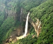
Caves and waterfalls also carry layers of meaning. Some are associated with legends, sacred places, or village histories, while others became prominent through exploration and tourism promotion. Nohkalikai Falls is linked with a well-known local story, and the surrounding plateau preserves evidence of how water, limestone, and monsoon erosion shape the land. Responsible visits should respect both the physical environment and the cultural significance of these places.
Today, Sohra combines family-run homestays, resorts, guides, restaurants, public viewpoints, and multi-day travel packages. Tourism provides income and creates opportunities for local employment, yet it also places pressure on roads, waste management, water resources, and fragile trails. The future of the destination depends on visitors recognizing that its natural beauty is part of a lived environment rather than a backdrop separate from local communities.
Planning A History-Rich Visit
A well-planned trip can bring together colonial history, Khasi culture, and the landscapes that made Sohra famous. Consider including time for the following:
- Visit viewpoints and waterfalls with a local guide who can explain the landscape and community context.
- Allow a full day for a living root bridge trek rather than treating it as a quick photo stop.
- Explore caves and forest paths with suitable footwear, especially during or after the monsoon.
- Learn a few local place names, including Sohra, and ask permission before photographing people or private spaces.
- Choose accommodations and tour operators that support local workers and encourage responsible waste practices.
The best season depends on the experience a traveler wants. The monsoon reveals the full force of Sohra’s waterfalls and cloud-covered cliffs, while drier months generally make trekking and road travel easier. Every season carries a different view of the region, from saturated green valleys to clear escarpment panoramas.
A two- to seven-night itinerary can include Sohra’s major attractions while leaving room for nearby villages, Shillong, Mawlynnong, or longer walks toward Nongriat. Travelers should check road conditions, carry rain protection, use reliable footwear, and keep essential medicines and identification documents accessible. International visitors should also review current visa and travel permission requirements before arriving in Meghalaya.
Sohra’s story is still developing. Its colonial past, Khasi heritage, ecological knowledge, and growing tourism industry meet in the same hills, making every journey more meaningful when visitors take time to understand what they are seeing. Explore the tours and vacation packages available through Cherrapunjee.net, and plan a Meghalaya visit that connects waterfalls, caves, living root bridges, and the history of Sohra in one memorable journey.